
.
Typhoon Matmo has wreaked havoc in Vietnam, destroying houses and infrastructure. A total of eight people died, and five others were injured due to heavy rains and floods.
According to the Vietnam Disaster and Dyke Management Authority, over 15 thousand 700 houses were submerged and more than 400 others damaged, while over 14 thousand 600 hectares of rice and other crops were inundated.
Flooding, landslides, and traffic disruptions occurred at 602 locations across northern mountainous and north-central provinces.
Prime Minister of Vietnam Pham Minh Chinh has called for intensified efforts to prevent flash floods and landslides and ensure safety for residents in affected areas.
The circulation of Typhoon Matmo have unleashed catastrophic flooding and landslides across northern Vietnam, claiming three lives, leaving four missing, and submerging nearly 10,000 hectares of paddies and crops.
As of October 7 evening, more than 4,800 houses were inundated and suffered damage, while major transport networks were badly affected. Local authorities are racing against time to settle the typhoon aftermath and ensure safety for residents in high-risk areas.
Floods, landslides, and traffic congestion were recorded at 493 locations on major routes in Lang Son, Cao Bang, Thai Nguyen, Bac Ninh, and Thanh Hoa provinces, according to the Ministry of Agriculture and Environment’s Department of Dyke Management and Disaster Prevention and Control.
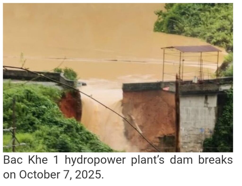
Notably, a 5-metre-wide breach was found at Bac Khe 1 hydropower dam in Tan Tien commune, Lang Son province, prompting the evacuation of downstream residents.
The Northern Power Corporation said that widespread inundation and landslides have severely affected power distribution, leaving over 262,000 customers without electricity. As of 14:00 on October 7, power was restored to about 19,000 customers, only 7.3% of those affected. Thai Nguyen suffered the most severe outages, with nearly 197,000 customers still in the dark, followed by Lang Son (25,000), Bac Ninh (15,000), and Cao Bang (7,000).
Meanwhile, the Vietnam Railway Authority and the Vietnam Railway Corporation reported flooding and landslides on the Hanoi – Dong Dang line in Lang Son and the Kep – Ha Long line connecting Bac Ninh and Quang Ninh provinces. The Vietnam Air Traffic Management Corporation said nearly 20 flights delayed or diverted due to persistent thunderstorms over Hanoi.
Cao Bang province faces particularly grave circumstances, with one dead and thousands affected. From the morning of October 6 through midday October 7, the province experienced widespread torrential rainfall of up to 200mm, triggering flash floods and landslides and submerging low-lying and riverside areas.
In Tuyen Quang province, numerous landslides were recorded, particularly along the Son Duong bypass, forcing authorities to close the route to ensure public safety. Rescue teams, military and police, and youth volunteers have worked to clear debris, dredge drainage network, and reinforce dikes and reservoirs.
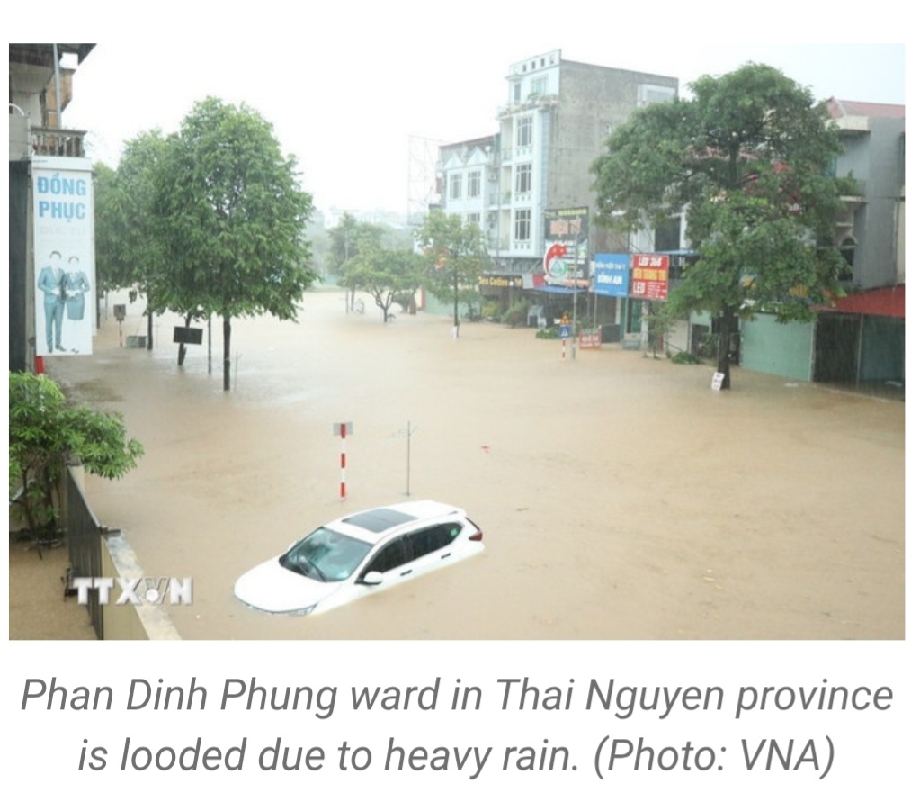
In Thai Nguyen province, heavy rain caused severe flooding and a massive sinkhole on National Highway 3B, paralysing traffic on this vital route. Emergency crews arranged barricades, installed warning lights, and regulated traffic flow.
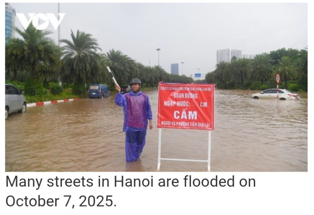
Hanoi, meanwhile, faced widespread flooding on October 7 due to prolonged downpours, with several areas receiving rainfall of up to 350mm. Pumping stations were operated at their maximum capacity to drain water from 90 flooded locations across the capital city./.VNA
Typhoon Matmo, known in the Philippines as Typhoon Paolo, was a strong tropical cyclone that affected Northern and Central Luzon and is currently traversing the northern South China Sea, threatening Macau, western Guangdong, as well as Northern and North Central Vietnam in early October 2025. The twenty-first named storm of the annual typhoon season, Matmo originated from an area of convection north-northeast of Yap that became a tropical depression on October 1.
[ On September 29, 2025, the Joint Typhoon Warning Center (JTWC) identified a low-pressure area approximately 241 nautical miles (446 km) north-northeast of Yap in the Federated States of Micronesia. Satellite imagery indicated a weak turning area with disorganized convective activity, primarily along the system’s western boundary.
The disturbance later entered the Philippine Area of Responsibility (PAR) and was named Paolo by the Philippine Atmospheric, Geophysical and Astronomical Services Administration (PAGASA) around 08:00 PHT (00:00 UTC) on October 1, with the Japan Meteorological Agency (JMA)[α] also starting advisories and classifying it as a tropical depression.
The JTWC also issued a Tropical Cyclone Formation Alert (TCFA) later that same day, citing tropical cyclone formation within the next 12 to 24 hours. The agency later followed suit and designated Paolo as 27W, with fragmented banding and flaring convection around the low-level circulation center (LLCC). Both agencies upgraded 27W into a tropical storm on the following day, with the JMA assigning it the international name Matmo as it tracked west-northwestward.
At 11:00 PHT (03:00 UTC), PAGASA upgraded Matmo to a severe tropical storm as satellite imagery showed improved organization, with deep convective banding wrapping into the LLCC in a favorable environment. The JMA later followed suit and also upgraded the system to a severe tropical storm early on October 3.
Both the JTWC and PAGASA subsequently upgraded Matmo to a minimal typhoon before it made landfall over Dinapigue, Isabela. As the typhoon brushed over Northern Luzon, satellite imagery revealed a well-defined, deep convective banding pattern wrapping into the LLCC of Matmo, featuring an impressive central dense overcast (CDO) and extensive feeder bands extending well beyond the island’s perimeter. PAGASA and the JTWC later downgraded Matmo to a mid-range tropical storm before it reemerged over the West Philippine Sea near Santa Cruz, Ilocos Sur at 17:00 PHT.
The JTWC re-upgraded Matmo to a typhoon around 09:00 UTC on October 4, as it showed improving convective banding around the LLCC and cooling cloud tops over the previous six hours.
The following day, Matmo reached its peak intensity as a Category 2-equivalent typhoon, with estimated one-minute sustained winds of 165 km/h (105 mph) and a minimum central pressure of 968 hPa (28.59 inHg).
Matmo later made landfall over Xuwen County in Guangdong at around 14:50 CST. It made another landfall over Guangxi early on October 6 as it entered the Gulf of Tonkin. Afterwards, Matmo weakened into a tropical storm as it moved inland over Vietnam, with the JTWC issued a final warning as it continued to deteriorate. ]
In Hanoi, the municipal drainage company has operated all pumping stations at full capacity to cope with flooding, according to General Director Phan Hoai Minh.
“We have mobilized maximum manpower and equipment and coordinated with relevant agencies to ensure effective drainage,” said Minh.
In Thai Nguyen, as flood levels on the Cau river threaten to surpass the historic 2024 record, provincial authorities have mobilized disaster response forces around the clock in critical areas and prepared equipment and materials to protect lives, property, and dikes.
“Localities have developed evacuation plans for residents in flood- and landslide-prone areas and are reinforcing vulnerable riverbanks and irrigation structures,” said Nong Quang Nhat, Vice Chairman of the provincial People’s Committee.
In Lang Son province, floodwaters caused Bac Khe 1 hydropower plant in Tan Tien commune to burst its dam on Tuesday afternoon.
“Local authorities and the plant have warned residents downstream to evacuate in time. However, power outages and rising floodwaters are hindering access to the affected site,” said Tan Tien Commune Chairman Hoang Ngoc Hung.
Also in Lang Son, dozens of homes have been damaged by landslides, while many roads, bridges, and low-lying crossings remain submerged.